 Equipo ViaParaguay
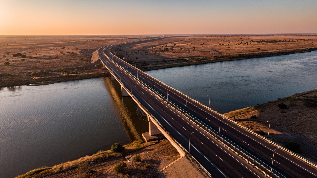
The Paraguayan Chaco, that dry and sparsely populated plain that for decades represented a geographic obstacle more than an economic asset, is on the verge of becoming one of the most important logistics corridors in South America. The Bioceanic Corridor, also known as the Bridge of Integration, is not a paper project: by mid-2026, the central structure connecting the two banks of the Paraguay River was just 13.6 meters away from closing its connection, with a formal completion date set for June 26, 2026. What for years was a promise of continental integration has become an engineering reality with a date on the calendar.
The scale of the project is difficult to grasp without geographic context. The corridor spans approximately 4,000 kilometers of road connecting Pacific ports — Matarani and Ilo in Perú, along with northern Chilean terminals — with the major Atlantic hubs of Santos and Paranaguá in Brasil, crossing Bolivia and Paraguay from west to east. For a continent that historically moved its cargo through Argentina or via maritime routes that doubled the distances, this connection represents a structural shift in regional logistics, not merely a time savings.
Paraguay occupies a singular geographic position within this route: it is the country where the corridor crosses the only major river separating the dry Chaco zones from the rest of the eastern territory. The bridge over the Paraguay River linking Carmelo Peralta, in the department of Alto Paraguay, with Puerto Murtinho in Brazil is the most complex piece of Paraguayan infrastructure in the corridor and, by extension, the most tangible symbol that the project is advancing. For investors analyzing Paraguay's real estate and logistics market, understanding this corridor is not an academic exercise: it is a variable that affects land values, infrastructure demand, and development prospects in areas that until recently remained off the economic map.
The Corridor That Connects Two Oceans
The idea of connecting the Pacific Ocean with the Atlantic through the heart of South America has circulated in regional integration forums for decades, but it was the concrete progress of construction works in Paraguay and Bolivia that transformed the concept into a project with a timeline and financing. The corridor crosses four countries: Perú and Chile as the Pacific gateway, Bolivia as the interior connection node, and Paraguay as the penultimate leg before entering the Brazilian port system. Each contributes distinct infrastructure, and each has different incentives for the corridor to succeed.
At the Pacific end, the ports of Matarani and Ilo in southern Perú are being modernized to receive larger cargo volumes that will no longer pass through the Panama Canal or circumnavigate the southern Argentine cone. Chile, for its part, is competing with its own northern terminals — Iquique, Antofagasta — to integrate into the corridor as a complementary alternative. At the Atlantic end, Santos is the largest port in Latin America and Paranaguá is the exit point for a significant share of Mercosur agricultural production. The fact that both ends are already operational and densely connected with domestic rail and road networks gives the corridor commercial viability from both directions.
Bolivia plays a dual role: it is the country that contributes the most kilometers to the interior route and also the one that benefits most from having sea access on two fronts. Santa Cruz and Cochabamba, Bolivia's two most economically dynamic cities, sit directly on the corridor's axis, giving them competitive access to Asian markets via the Pacific and European markets via the Atlantic without depending solely on the Chilean port of Arica. For Bolivia, the Bioceanic Corridor is as much a project of commercial sovereignty as it is one of infrastructure.
Paraguay, by contrast, arrives at this corridor with an already consolidated position as a world-class agricultural producer. The corridor does not create the Paraguayan economy; it amplifies it and opens more direct and cheaper export channels. The difference between the current situation and what the corridor will generate is not in the type of production, but in logistics costs, transit times, and competitiveness in the international market for commodities and manufactured goods.
Current Status of the Works: Meters Away from a Historic Milestone
The most anticipated piece of all Paraguayan infrastructure in the corridor is the bridge over the Paraguay River, connecting Carmelo Peralta, in the department of Alto Paraguay (Chaco region), with Puerto Murtinho in the Brazilian state of Mato Grosso do Sul. By mid-June 2026, the bridge decks were just 13.6 meters from meeting — a distance technically shorter than the length of an articulated truck, but one that represented years of engineering, financing, and coordination between the Paraguayan state and the construction companies involved. The formal closing date was set for June 26, 2026.
The physical progress of the bridge does not occur in isolation. Along the Paraguayan Chaco, the road connecting the bridge with the Bolivian border — passing through Pozo Colorado, Filadelfia, and Mariscal Estigarribia — has been the subject of road improvement works that, while not always visible from Asunción, radically change transit conditions for heavy cargo trucks. The route is arid, long, and demanding; improvements to the asphalt surface and drainage systems are critical for the corridor to function under variable weather conditions, including the Chaco rainy season that historically made certain stretches impassable.
The inauguration of the bridge does not mean, however, that the corridor will be fully operational from day one. The Bolivian sections of the corridor — especially those connecting the Paraguayan border with Santa Cruz and those descending from Santa Cruz toward the Peruvian border — have varying degrees of completion. Some stretches are already high-quality paved roads; others still require investment in paving or rehabilitation. This unevenness is one reason the corridor will develop in functional phases rather than through a single grand opening.
What the bridge's closure does represent is the fulfillment of the most visible and politically significant commitment of the corridor on Paraguayan soil. For the Paraguayan government, it is also a concrete argument in its investment attraction agenda: the country has its portion of the infrastructure completed. That gives it standing in regional negotiations over transit tariffs, customs protocols, and transit facilitation for carriers from all four countries.
Paraguay at the Center of the Logistics Map
For decades, Paraguay was a country with transit almost exclusively to the south: its exports left via the Paraná River toward Uruguay and Argentina, and its imports arrived by the same waterway. That dependence on the southern axis was functional while Argentina represented the cheapest and most reliable route, but it also left Paraguay exposed to the cycles of political and economic instability of its largest neighbor. The Bioceanic Corridor opens an entirely different axis: the west-east axis, which does not pass through Argentina.
This geometry has important practical consequences. Paraguayan exports of soybeans, beef, and agro-industrial products that currently leave via the south will also be able to do so via the east, using the Brazilian ports of Santos and Paranaguá, which are already among the most efficient in South America. Freight rates, transit times, and port service reliability are variables that will determine how much of Paraguay's trade shifts to this route. Preliminary analyses suggest that for cargo destined for Asia — the primary market for Paraguayan soybeans — the Pacific route can be significantly faster than the southern Atlantic route.
The fact that Argentina is excluded from the main corridor is no minor detail. Historically, Argentina has been both a commercial ally and a point of friction for Paraguay, especially during periods of regional political tension. The Bioceanic Corridor reduces that structural dependence and diversifies the country's logistics options in a way that no prior bilateral agreement had achieved. For investors, this means Paraguay gains commercial autonomy, reducing one of the historical risk factors of its economy.
The Chaco: From Forgotten Land to Transit Hub
The Paraguayan Chaco is, in demographic terms, one of the emptiest spaces in South America: it occupies 60% of the national territory but is home to just 3% of the population. Its traditional economy is based on extensive cattle ranching, the crops of Mennonite communities, and some extractive activities. Until a few years ago, most of the Chaco lacked continuous paved roads and basic services lagged decades behind eastern Paraguay.
The corridor radically transforms the territorial function of the Chaco. Pozo Colorado, the first significant population center encountered on the Chaco road after crossing the bridge, will transition from a rest stop for drivers to a logistics services node: fuel, vehicle repair shops, temporary storage, communications services, and accommodation for corridor operations teams. Filadelfia, the largest city in the central Chaco and the de facto capital of the Mennonite colonies, already has installed service infrastructure and could absorb more complex functions such as refrigerated distribution, fleet maintenance centers, and value-added cargo services.
Mariscal Estigarribia, on the road toward the Bolivian border, is the corridor's entry and exit point on the Paraguayan side. Its function as a customs and cargo control post makes it a potential logistics activity hub. Demand for land to support transport infrastructure — truck yards, grain silos, cold storage facilities, commercial-scale fuel installations — is already being registered by operators in the sector. Land prices in these locations, historically very low due to scarce demand, will begin to reflect their new functional role.
Direct Impact on Paraguayan Exports
Paraguay is the world's fourth-largest soybean exporter and one of the four largest beef exporters on the planet. Those positions in the global market are not the result of an interventionist state or massive subsidies: they are the result of soil conditions, production scale, and relatively low costs that have made the Paraguayan agricultural sector competitive against larger producers. What has consistently limited that competitiveness is logistics costs: moving a container from the Paraguayan interior to an Asian market today involves long river journeys, transshipments, and tariffs that erode producer margins.
The Bioceanic Corridor directly targets that bottleneck. For Paraguayan soybeans destined for China — the world's largest buyer of the grain — the possibility of exiting through Peruvian Pacific ports rather than navigating the entire Paraná to the Atlantic represents a reduction in transit days that translates directly into lower financial costs. Grain that today takes weeks to reach an Atlantic port from farms in northern Paraguay could make the same journey in less time via the Bioceanic land route to Matarani or Ilo, then cross the Pacific.
For beef, the implications are different but equally relevant. Paraguay exports refrigerated and frozen beef to markets including Chile, China, Israel, and several European countries. Maintaining the cold chain during land transport is a non-negotiable requirement, and the corridor will only be competitive for beef if cold-chain infrastructure is developed along the Chaco and Bolivian route. This in turn generates specific investment demand for intermediate cold storage facilities, which is part of the logistics opportunity profile the corridor activates.
Beyond commodities, the corridor has implications for the light manufacturing that Paraguay has begun to develop in recent years. The maquiladora industry, which produces manufactured goods under the maquila regime for export, could gain access to Pacific markets at lower transport costs. This does not guarantee that industry will develop in corridor municipalities, but it does mean the corridor broadens the competitive reach of what is already produced in Paraguay.
Real Estate and Logistics Opportunities
Discussing real estate opportunities in the context of the Bioceanic Corridor requires distinguishing between asset types and time horizons. Analyzing the logistics land market in Pozo Colorado — where demand is specific, technical, and tied to transport operators — is not the same as analyzing the residential market in Concepción, which responds to more complex dynamics of internal migration, urban development, and services. The corridor affects both markets, but in different ways and on different timescales.
Logistics land and transport support infrastructure are the assets most directly tied to the corridor. Truck yards, large-scale fuel stations, heavy mechanic shops, goods transit depots, refrigeration systems for perishable cargo: all these uses require land well positioned along the route, with access to basic services and preferably with clear title. In the Chaco, where land tenure has historically been irregular and cadastral records have gaps, legal title clearance is a prerequisite for any institutional investment.
Concepción and Northern Paraguay
Concepción is the most important city in northern Paraguay and the closest urban reference to the corridor on the eastern side of the country. With a population of around 70,000, it has urban services the Chaco does not: hospitals, universities, banks, hotels, and an established commercial structure. The Bioceanic Corridor, whose international bridge is located at Carmelo Peralta to the north, positions Concepción as the primary urban services hub of the northern Paraguayan axis, accessible by road from the corridor's route.
The Concepción real estate market has historically been quiet: low prices, little speculation, and a relatively stable local demand. The corridor introduces new variables. The arrival of transport operators, agro-export companies seeking to establish themselves near the corridor's head, and professionals linked to customs management and logistics creates demand for commercial spaces, warehouses, and executive housing that the local market was not producing. That demand does not appear overnight, but its trajectory is upward.
The land market on the outskirts of Concepción and in municipalities adjacent to the bridge — such as Puerto Vallemí to the north or the direct access roads from the Concepción-Pozo Colorado route — is where the earliest impact may be felt. Parcels with road frontage, historically worth very little, are beginning to be viewed as candidates for warehouses, expanded service stations, and trucker support services. For an investor with a medium-term horizon, these parcels represent a different type of asset from urban residential: less liquid, more specialized, but with appreciation potential tied to the traffic volume that actually uses the corridor.
The Western Chaco
The western Chaco — the stretch from the bridge to the Bolivian border — is the territory where the potential transformation is most dramatic in relative terms, but also the one presenting the greatest uncertainty in terms of timeline. Pozo Colorado, Filadelfia, and Mariscal Estigarribia are three reference points along this stretch, each with distinct characteristics and different potential roles within the corridor's logistics ecosystem.
In Pozo Colorado, the most immediate demand is for basic support infrastructure: fuel stations capable of serving fleets, safe rest areas for drivers, small spare parts depots for trucks. Land in Pozo Colorado is cheap and available, but the lack of reliable basic services — stable electricity, drinking water, connectivity — is a real obstacle to more complex investments. Chaco municipalities are working to close these gaps with support from the central government, but the pace of those improvements will determine what types of private investment can arrive and when.
Filadelfia holds a differential advantage: the Mennonite colonies have developed over decades a productive and services infrastructure that includes cold storage plants, agro-industrial cooperatives, high-capacity mechanical workshops, and their own water supply systems. This existing base makes Filadelfia the node with the greatest capacity to absorb complex logistics functions in the short term. Interest in industrial and commercial land on the outskirts of Filadelfia is already being felt among regional operators monitoring the corridor's progress.
Mariscal Estigarribia is the most speculative case of the three. Its proximity to the Bolivian border makes it a candidate to become a free zone or customs services area, but this depends on public policy decisions that have not yet been formalized. If robust customs infrastructure is indeed installed in Mariscal Estigarribia, the land market in its immediate surroundings would undergo a transformation comparable to what border zones experienced in other logistics corridors on the continent. If that infrastructure is located elsewhere, the speculation in Mariscal Estigarribia would be left without foundation.
What the Numbers Say: Trade and Projections
Projections of increased commercial flow associated with the Bioceanic Corridor range from USD 1.8 billion to USD 2 billion annually at the regional level. This figure includes trade that will be diverted from existing routes to the corridor, plus new trade generated by improved regional logistics competitiveness. Not all of that flow passes through Paraguay: the figure covers the entire corridor, which involves four countries. Paraguay's share will depend on what fraction of traffic uses the Concepción-Chaco-Bolivia axis and what fraction uses alternative Brazilian or Bolivian routes.
To contextualize the scale, it is worth comparing with Paraguay's current exports. The country has exported between USD 12 billion and USD 14 billion in goods annually in recent years, with soybeans and their derivatives representing more than 40% of that total. A regional commercial flow increase of USD 2 billion does not by itself transform that structure, but it can reduce logistics costs enough to make competitive exports that are currently at the edge of profitability, or to make new geographic destinations accessible to Paraguayan producers who today cannot reach them with positive margins.
Fiscal impacts are also relevant. A higher volume of international transit generates revenues from customs duties, port services, and fuel. If Paraguay succeeds in positioning itself as a services zone for the corridor — and not merely a transit country — the corridor's fiscal contribution could over time exceed revenues directly tied to transit. This requires active logistics investment attraction policies, well-regulated bonded warehouse zones, and customs infrastructure that functions as a facilitator rather than an obstacle.
In terms of employment, the corridor generates jobs in at least three categories: direct employment in infrastructure construction and maintenance, employment in transport support services along the route, and indirect employment in agro-industrial activities whose competitiveness improves due to lower logistics costs. Precise quantification of these jobs is difficult without operational data from a functioning corridor, but patterns observed in other logistics corridors on the continent suggest that the impact on formal employment is significant and sustained over time as the corridor gains volume.
Risks and Realistic Timelines
The most immediate risk of the Bioceanic Corridor is not engineering, but regulatory integration. Four countries with different customs systems, different transport legislation, non-harmonized phytosanitary requirements, and their own cargo control procedures must coordinate their operations in real time for the corridor to function with the fluency that justifies the investment. Latin America's experience with prior bioceanic corridors shows that infrastructure is built faster than regulatory integration. A truck can cross the bridge in minutes; the full customs process can take hours or days if protocols are not harmonized.
The state of the Bolivian stretches is another critical variable. Bolivia has the corridor's longest stretch by distance and also the most heterogeneous in infrastructure quality. The stretches between Santa Cruz and the Paraguayan border have been significantly improved in recent years, with partial financing from regional integration funds. But the stretches between Santa Cruz and the Peruvian border — those that complete the connection to the Pacific — still have unpaved segments or deteriorated pavement. Until those stretches are fit for continuous heavy cargo traffic, the corridor will operate partially: useful, but not as efficient as the projected scenario.
Regulatory harmonization among the four countries involves more than customs procedures. Maximum vehicle weight and dimension limits differ between countries, which may require transshipment of goods at border crossings. Insurance requirements for carriers also vary, and the lack of mutual recognition of professional driver licenses can create operational bottlenecks. These are not unsolvable problems, but they require specific intergovernmental agreements that take time to negotiate, ratify, and implement.
For those analyzing the specific real estate impact, the realistic horizon for full materialization is five to ten years from the bridge opening. This does not mean there will be no movement beforehand: the first shifts in the Chaco logistics land market are already being recorded, and the interest of regional transport operators in establishing a presence in Concepción and Pozo Colorado is verifiable. But the full transformation of the economic profile of these cities requires the corridor to have reached sufficient traffic volume to justify investments at scale.
There are also macroeconomic risks that should not be ignored. Commodity prices — soybeans and beef in particular — are volatile, and a sustained drop in international prices can reduce the incentive to invest in export logistics, even if the corridor is operational. Bolivia's political cycles, which directly affect transit conditions through that country, are another variable beyond Paraguay's control. And competition from other regional logistics corridors may redirect some of the flow the Bioceanic Corridor aspires to capture.
The Chaco real estate market also has its own characteristics that limit the speed at which outside capital can enter. Irregular property titles, territorial disputes in some areas, outdated cadastral records, and low market liquidity are factors that make Chaco land a more suitable investment for operators with deep local knowledge than for portfolio investors without experience in the Paraguayan market.
Conclusion: Positioning Before the Corridor
The Bioceanic Corridor does not rewrite Paraguay's economy overnight. What it does is gradually alter the structural conditions under which that economy operates: it reduces dependence on a single sea exit route, improves the logistics competitiveness of agricultural exports, activates zones that until now have been off the productive map, and generates new demand for infrastructure at specific points across the territory. These changes are real, are underway, and have measurable effects on the asset market, employment, and the country's investment profile.
The relevant question for an investor is not whether the corridor will have an impact — that is already demonstrated by the physical progress of the works — but when that impact becomes fully legible in market numbers. The honest answer is that the logistics land market in the Chaco will begin to move before the urban residential market in Concepción, which in turn will move before the office or services market in Asunción. Each asset type has its own reaction timeline to an infrastructure transformation of this scale.
Operators who position themselves before demand becomes widespread capture the differential between land prices in a region perceived as peripheral and prices once that perception has changed. That differential exists today in the Paraguayan Chaco, in Concepción, and in the municipalities along the northern axis. It does not exist, by contrast, in the Asunción markets or in the consolidated zones of eastern Paraguay, where prices already incorporate the country's growth expectations. The Bioceanic Corridor redistributes economic geography within Paraguay: it transfers value toward the west and north, with a logic grounded in real infrastructure.
For investors and expatriates following the Paraguayan market, the closing of the bridge over the Paraguay River on June 26, 2026 is a date worth marking. Not because it changes everything immediately — it does not — but because it marks the moment the corridor transitions from a work in progress to infrastructure in service. From that point on, cargo flows will begin to accumulate, logistics operators will start making location decisions, and the municipal governments of the Chaco and northern Paraguay will receive investments that until now were only under evaluation. Infrastructure is completed before the economy it generates. But the economy arrives.